


Know the 12 bridges
Minato-bashi Bridge (completed in March 1967)
It is a steel girder bridge. On the right bank side of the Gonokawa River is Prefectural Road No. 291, which is a port area in the Kimidani area.
The left bank side is Prefectural Road 40, and it is the Take area in Ago. There is Take Station of former-Sanko Line nearby.
The name of the bridge is written in hiragana.
We thought it was "Minato-bashi" with kanji of 港(minato) from name of the district, but the bus stop on the right side of the bridge says "Minato-bashi" with kanji of 湊(minato).
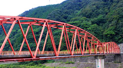
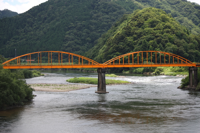
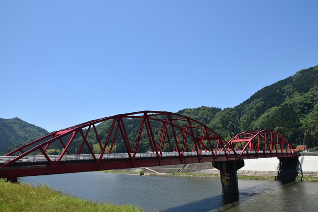
Kurihara-bashi Bridge (completed in March 1976)
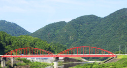
It is a 2 arch bridge. It's a bridge on the Kurihara Line of the town road.
The color of the bridge is vermilion and very conspicuous.
It is built in the Kurihara district of Ago.
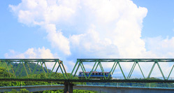
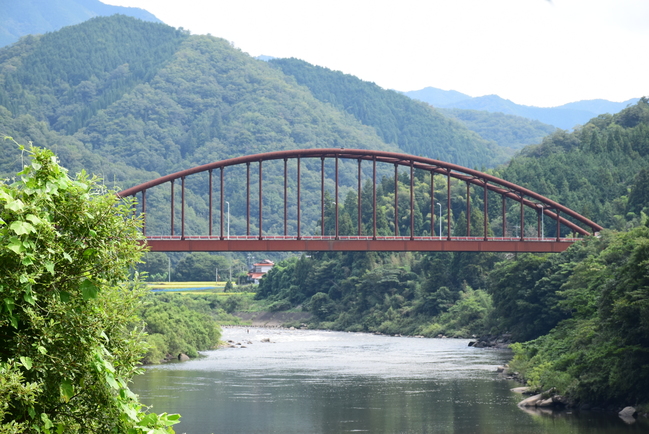
Ago Ohashi Bridge (completed in March 1954)
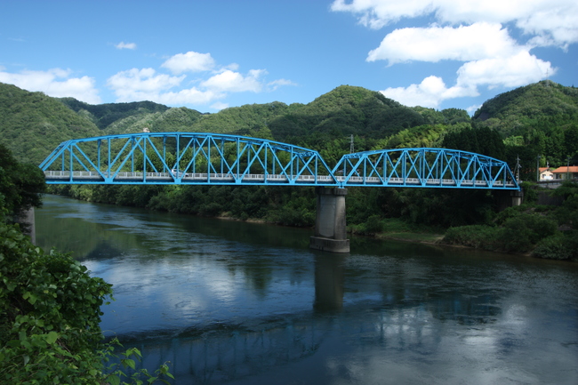
This is a 2 truss bridges. It is an old bridge even in Gonokawa River.
The painted color of the bridge is light blue, and it looks bright.
It is a bridge that prefectural road 40 passes through, and Sanko Line runs on the left bank side, but there is "Iwami-Yanaze Station" on the slightly downstream side and "Akatsuka Station" on the upstream side.
Near Akatsuka Station is the Akatsuka Power Station, which generates electricity from water stored in the Hamahara Dam. It connects the Ago and Yanaze districts of Ago.
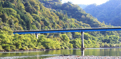
Former Sanko Line Railway Bridge
It is a 3 truss type steel bridge.
It is located about 100 meters downstream of Akebono-bashi, and the Akebono-bashi is also hidden in the back of the photo.
There is the "former Kasubuchi Station" on the right bank side. It spans Kasubuchi and Noi districts in Kasubuchi.
It used to be a famous railroad bridge that you can walk on, but unfortunately, it became unavailable to enter due to the Sanko Line abolishment.
Now it is only a trace of Sanko Line.
Akebono Ohashi Bridge (completed in September 1992)
The Misato Town is the tip of the Gonokawa River that protrudes to the north in a convex shape.
It flows north to Misato Town and changes direction to south here.
This Akebono-bashi is a bridge that connects the Kasubuchi area (north of river) and the Noi area (south of river).
It is a concrete rigid frame bridge.
Hamahara Ohashi Bridge (completed in March 1975)
It is a 2 arched bridges. It connects the Hamahara and Takibara districts of Hamahara.
There is Hamahara Station of Sanko Line in front of the bridge. If you go downstream on the left bank side of the river, there is a Canoe-no-Sato Campsite and its museum, which is a great point for people who canoe. It is also a spot where you can see Sanbe Mountain. The Japan National Route 375 Line runs by the river, but it runs through a tunnel in the mountain before the bridge as a bypass.
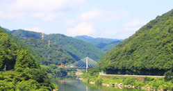
Shiki-bashi Bridge (completed in March 1979)
Its name, 信喜橋, is read as "Shikibashi." It is a steel suspension bridge. You can drive through.
This is the site where canoeing events are held, and it became the venue for canoeing of the national body in 1982. We heard that the emperor saw canoeing from this bridge when he was a crown prince.
The water level is rising because of the Hamahara Dam downstream of this bridge. It is a scenic spot where the Shiki Bridge reflected on the water surface and the mountains are very beautiful. It connects the tidal area with the Takibara area in Hamahara.
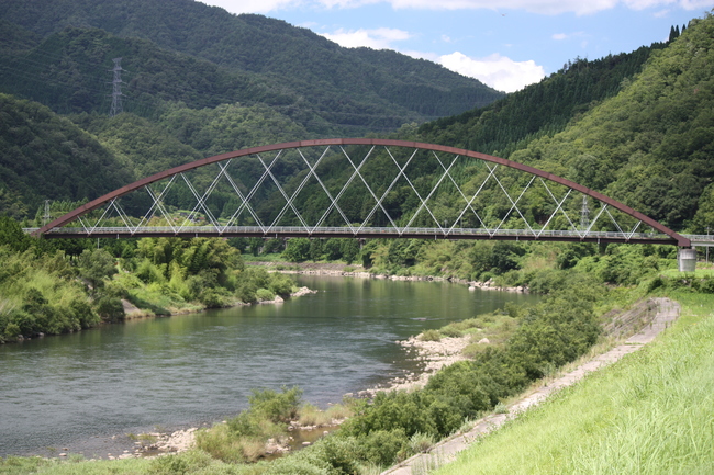
Tsugayuki Ohashi Bridge (completed in March 1973)
It is a steel arch bridge. It was restored in 1975 after it was washed away by flood in 1974.
It is a bridge from the Japan National Route 375 Line (near Iwami-Matsubara Station in Sanko Line) to the Tsugayuki area. The yellow color stands out well. Just behind the bridge, on the left side, there is a small mountain called Mitamayama, which was once located in the river.
There was a castle called Mitamayama Castle in this mountain, and it is said that they did not lose because of the location.
Takanashi Ohashi Bridge (completed in March 1984)
It is the only cable-stayed bridge in Gonokawa River. It is a 2 span continuous cable-stayed bridge with a length of 158m and a span length of 100m.
It is the twenty-ninth cable-stayed bridge in Japan.
The right bank side is the Nagato area where Japan National Route 375 Line runs, and the left bank side is the Tsugayuki area where the prefectural road runs.
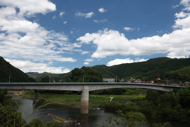
Daiwa Ohashi Bridge (completed on March 20, 2003)
This is a dark brown arch bridge. When you cross the bridge, you will see a magnificent road leading to the Hinomiya area.
It is the newest of the 11 bridges in Misato Town and was completed in 2003.
The right bank side is the Nagato area, but there is a road that goes to Iinan Town nearby, and it connects to Shimoakana, the Idodani area of Iinan Town.
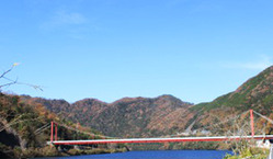
Oura-bashi Bridge (completed in November 1989)
It is the only Nielsen Lohse bridge in the Gonokawa River.
This bridge won the Shimane Prefecture Landscape Award in 1993.
It is a very beautiful bridge, and it is rare that the color of the coating is violet, so you can see the beautiful scenery from the Roadside Station Green Road Daiwa.
The width of the bridge is less than 4m and it has 1 lane.
The left bank side is the Oura area and the name of the bridge comes from the name of the district.
Tsuga Ohashi Bridge (completed in March 1978)
It is the trussed Langer girder bridge.
This kind of bridge is only here in Gonokawa River.
Sanko Line runs through a tunnel on the right side of the bridge. Japan National Route 375 Line also runs along the river on the right side of the bridge. This bridge is on Prefectural Road 55 (Mizuho Akagi Line). The bridge used to be painted in blue, but now it is painted in red.
There is the former Tsuga Elementary School on the left bank side, and the school building of Daiwa Elementary School is now built there.