


Know the Ginzan Kaido Roadway
The Iwami-Ginzan Silver Mine Site was registered as a World Heritage site, which is still fresh in memory. The prosperity of Iwami Ginzan Silver Mine was greatly related to the surrounding area. Here in Misato Town, the "Ginzan Kaido" (Silver Mine Roadway), which was used to transport silver and supplies for silver refining, remains almost unchanged from the past.
Congratulations! Designated as a national historic site! (February 13, 2018)
Among the Iwami Ginzan Kaido of Misato Town, "Yanashio-michi" and "Morihara Kodo" were designated as National Historic Sites by the Agency for Cultural Affairs on February 13, 2018, as transportation routes for the Iwami Ginzan Silver Mine.
Misato Town and Ginzan Kaido (Silver Mine Roadway)
The Iwami-Ginzan Silver Mine Site was registered as a World Heritage site, which is still fresh in memory. The prosperity of Iwami Ginzan Silver Mine was greatly related to the surrounding area. Here in Misato Town, the "Ginzan Kaido" (Silver Mine Roadway), which was used to transport silver and supplies for silver refining, remains almost unchanged from the past.
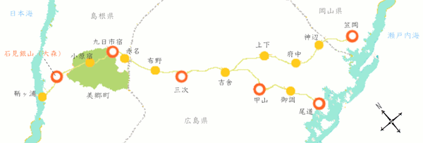
Most of the silver mined in the Iwami Ginzan Silver Mine was transported to Hakata in the Kyushu region in the first half of the sixteenth century. The loading port at this time was Tomogaura Port on the Japan Sea side.
After that, however, more silvers were transported to the Kansai area and Kyoto, and Onomichi, a port for shipment to the then-largest city of Kyoto-Ginza, and a land route for shipment to Kasaoka, Okayama, a port for shipment to the Kansai area, were established. This is the "Ginzan Kaido" that still remains.
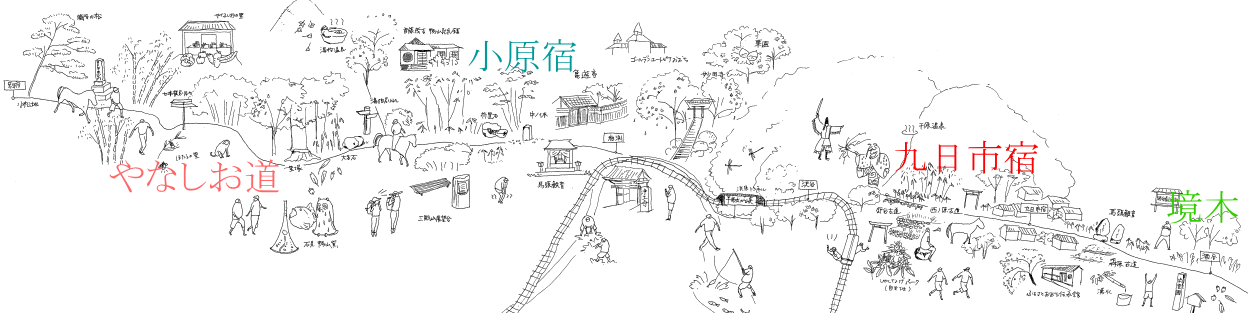
It is said that the 300 horses and 400 people of the big transportation unit used to walk a day from Omori and arrived at Kokonokaichi around 8 at night.
The second day, they arrived to Miyoshi, and the third day to Kozan, and it took 4 days to reach Onomichi.
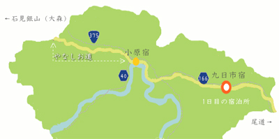
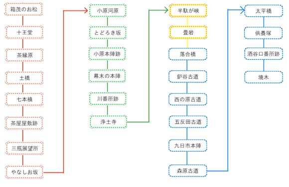
In Misato Town, "Ohara-juku" and "Kokonokaichi-juku" shown above were set up. In particular, Kokonokaichi-juku was the first-day accommodation on the way between Omori and Onomichi 4 days 3 nights trip. In Ginzan Kaido in the town, the road west of Oharajuku is called Yanashio-michi.
There are various theories about the origin of the name, but it is not certain. One theory is that it is because it was a road that carried a lot of salt, where yana means a lot and shio means salt. It is considered that "八名塩道(literally: eight name salt road)" changed to "やなしお道" is a dominant theory.
This Yanashiomichi has been selected as one of the 100 Rekishi-no-Michi Selections by the Agency for Cultural Affairs (currently the Ministry of Education, Culture, Sports, Science, and Technology).
Around Kokonokaichi-juku, the roads such as Tataradani Kodo and Morihara Kodo continues, and continue to the Sakaigi, which is between neighboring town Iinan Town. This Sakaegi divided not Misato Town and Iinan Town but the former "Iwami Province" and "Izumo Province." Don't you feel experiencing time slip?
Misato Town Iwami Ginzan Silver Mine Roadway Route (Japanese)
・Download Ginzan Kaido Roadway Pamphlet (Japanese)
・ Omori~Miyoshi → ![]() 「石見銀山街道 大森~三次」をダウンロードする(PDF:19.1MB)
「石見銀山街道 大森~三次」をダウンロードする(PDF:19.1MB)
・ Miyoshi~Onomichi → ![]() 「銀山街道 三次~尾道」をダウンロードする(PDF:14.5MB)
「銀山街道 三次~尾道」をダウンロードする(PDF:14.5MB)
・ Uga~Sasaoka → ![]() 「銀山街道 宇賀~笠岡」をダウンロードする(PDF:16.6MB)
「銀山街道 宇賀~笠岡」をダウンロードする(PDF:16.6MB)